Planetary Envrionment
The Planetary Environment is a flexible Nishita sky model. It is useful when rendering scenes set in outer space. For its effects to be visible, the camera has to have a very high altitude as it moves to outer space to view the expansive horizon of the planetary body. It takes into account the conditions within and beyond the atmosphere of a planetary body and its surroundings in space. Instead of a single ground color and a sky or sunset color, there is a planetary surface that reflects and emits light.
This node extends the environment's medium (volume rendering and subsurface scattering) with an atmospheric scattering through the planetary body's atmosphere. The atmosphere is perceived as a layer of gas surrounding a planetary mass. It is held in place because of gravity, so as the light travels into atmosphere either from the outer layer to the ground or from a light source within the atmosphere, then the atmosphere's density is sampled along the ray at regular intervals, resulting in an amount of scattering based on the atmosphere's density. This atmospheric scattering is based on the Nishita Sky model, which displays the variations of color that are optical effects caused by the particles in the atmosphere.
This environment is not connected to the camera, so you can zoom the camera in and out of the scene without affecting the environment's position in the scene. It gathers optical depth (transmittance) from the sun position, so if the sun position is above the horizon, then the environment it will be colored. If the sun position is below the horizon, then it will not gather transmittance, making it invisible Figure 1).
|
|
Planetary Environment
|
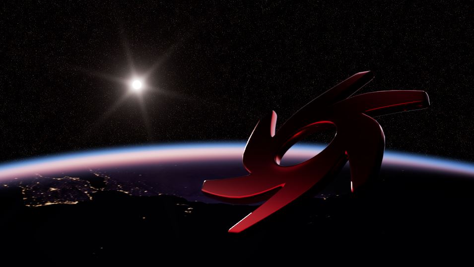
Figure 1: Accessing the Planetary Environment node from the Node Graph Editor window
The Planetary Environment node can be accessed by right-clicking in the Node Graph Editor, then navigating to the Environments category, and then clicking on Planetary Environment (figure 2).
|
|
Planetary Environment
|
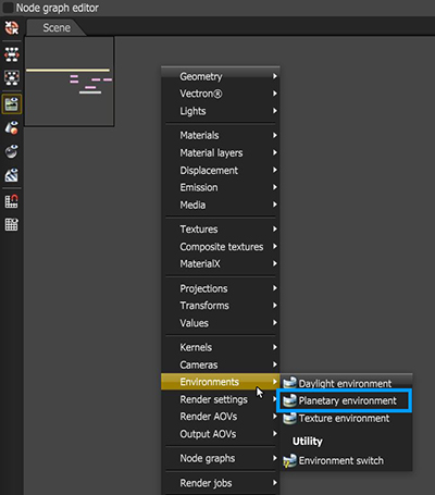
Figure 2: Image rendered using the Planetary Environment with the camera set at a very high altitude
Planetary Environment Parameters
The Planetary Environment system uses sun direction as the method for controlling the direction of the lighting.
- Longitude/Latitude - Get realistic sun settings for the specified geographic location.
- Month/Day/GMT Offset/Local Time - These parameters can accurately place the sun in the sky according to the date/time for the sun at the current longitude/latitude.
- Interactive Map - The map can set the scene's geographic location. The sun's position can be set by dragging the crosshairs around on the map (Figure 3).
|
|
Interactive Map
|
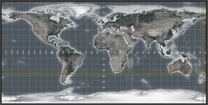
Figure 3: An interactive map for sun position
Sky Turbidity - Adjusts the sunlight shadow's sharpness. Low values create sharp shadows similar to a sunny day, and higher values diffuse the shadows similar to a cloudy day.
Power - Adjusts the overall strength of the Planetary Environment's illumination.
Sun Intensity - Scale factor that is applied to the sun only, used to adjust the relative power of the sun compared to the sky. Note: Values other than 1.0 can produce unrealistic results.
North Offset - Adjusts the scene's actual North direction. This is useful for architecture visualization to ensure the sun's direction is accurate to the scene.
Sun Size - Controls the size of the sun given as a factor of the actual sun diameter.
Altitude - The camera's altitude. Set this to a very high value in order to view the expansive horizon of the planetary body.
Star Field - Texture that conveys star fields behind the planet.
Importance Sampling - This toggles the texture importance sampling which enables quicker convergence (noise reduction) for HRDI images by applying importance to certain areas of the HDRI.
Cast Photons - If photon mapping is used, this will cast photons from bright areas in the environment map.
Medium - This parameter accepts an Absorption, Scattering, or Volume medium node to create volume/fog effects across the scene. For more information, see the Volume Fog Effects topic under the Effects category in this manual.
Medium Radius - Adjusts the medium's scale.
Medium Light Pass mask - Enables or disables lights on the scattering environment medium.
Latitude - The latitude coordinate of the camera's current position.
Longitude - The longitude coordinate of the camera's current position.
Planetary Surface Parameters
Ground Albedo - Color or texture map applied to the planetary surface.
Ground Reflection - The specular texture map on the planet.
Ground Glossiness - The planetary glossiness.
Ground Emission - The planet's surface texture map at nighttime.
Ground Normal Map - Normal map on the planet.
Ground Elevation - Elevation map on the planet.
Trace Sets
The Trace Set system allows for greater control over including or excluding scene data from object surfaces when light hits the surface.
Visible Environment
Nodes connected to the Environment pin on a Render Target node are considered the primary environment. Nodes connected to the Visible Environment pin on a Render Target node provide a way to separate the background, reflections and refractions from the primary environment. Both the Environment and the Visible Environment pins accept Daylight, Planetary, and Texture environment nodes.
|
NOTE Only when one of these nodes are connected to the Visible Environment pin on a Render Target will the Backplate, Reflections, and Refraction parameters be functional. Activating the checkboxes listed below when connected as Environment node parameters will have no effect. Please see the Visible Environment topic for more details. |
Backplate - Uses the environment specified in the Visible Environment node as the background.
Reflections - Uses the environment specified in the Visible Environment node as the scene object reflections.
Refractions - Uses the environment specified in the Visible Environment node as the scene object refractions.